Vøring Sampling
Edited by Stéphane Polteau, Mikal Trulsvik, Nina Lebedeva-Ivanova, and Sverre Planke

The aim of the VS16 survey was to document a working Jurassic system by identifying oils seeping to the seabed along the outer Vøring Basin. Mature Jurassic source rocks are interpreted to be present within structural highs beneath the breakup basalt successions based on paleogeographic reconstructions and geological evidence.
The seep results indicated the presence of seeped thermogenic hydrocarbons in seabed sediments particularly in the Fenris Graben and over the Naglfar Dome, identifying "hot areas" that should be the focus of future exploration programs.
Highlights
• Gravity cores from 36 stations
• In total 105.51 m of sediment cores recovered
• All sites evaluated using MPOG, AGI, and APT analytical methods
• Basalt sample and manganese nodules dredged from the Vøring Escarpment
Database and deliverables
• Interpretation report and ArcGIS project
• Sub-bottom profiler data
Results from report integrated in the "North Atlantic Margin Sampling 2018" - NAMS18
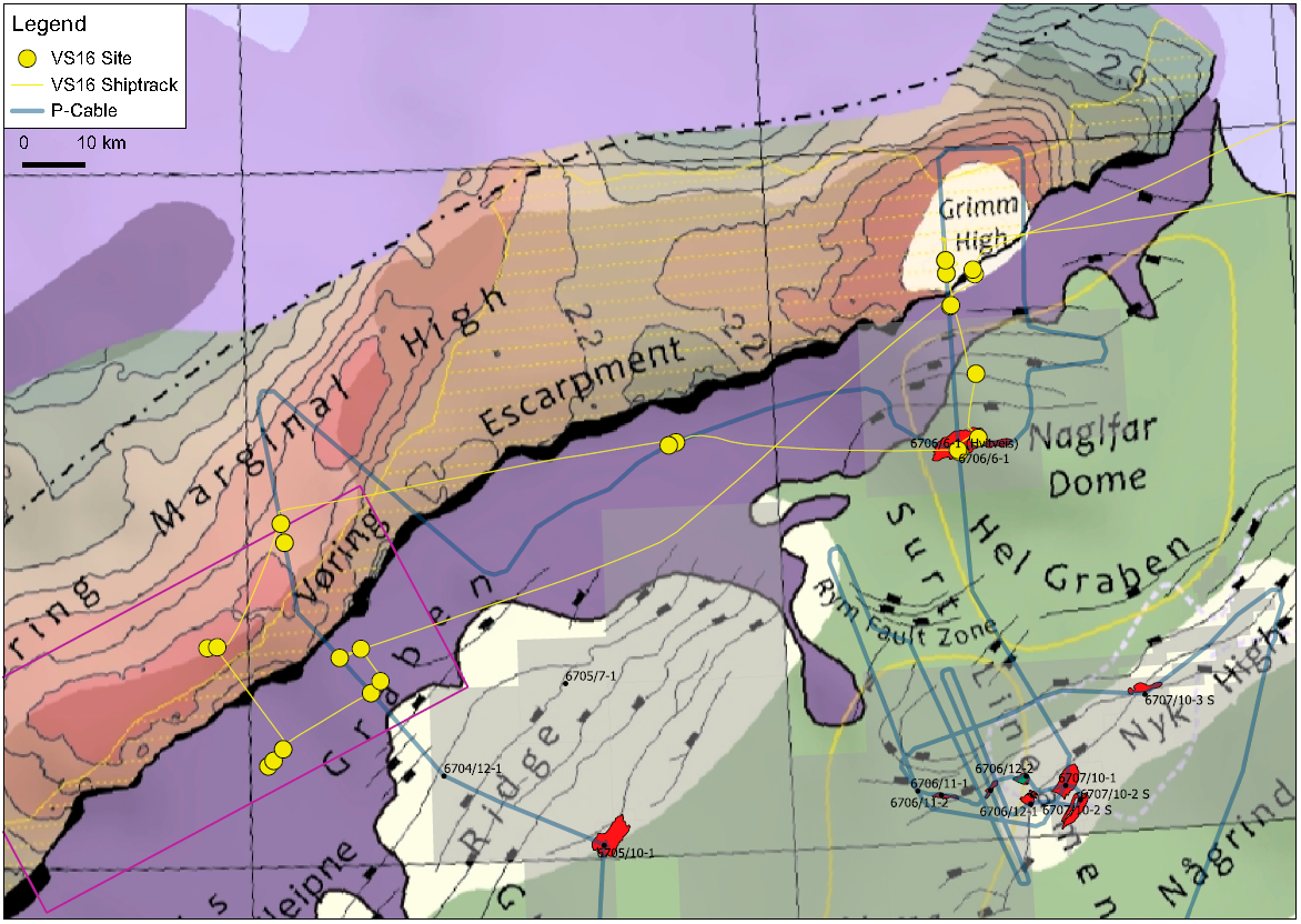
VS16 sites and ship track overlaid on the Mid-Norway nomenclature map of Trulsvik et al. (2012).
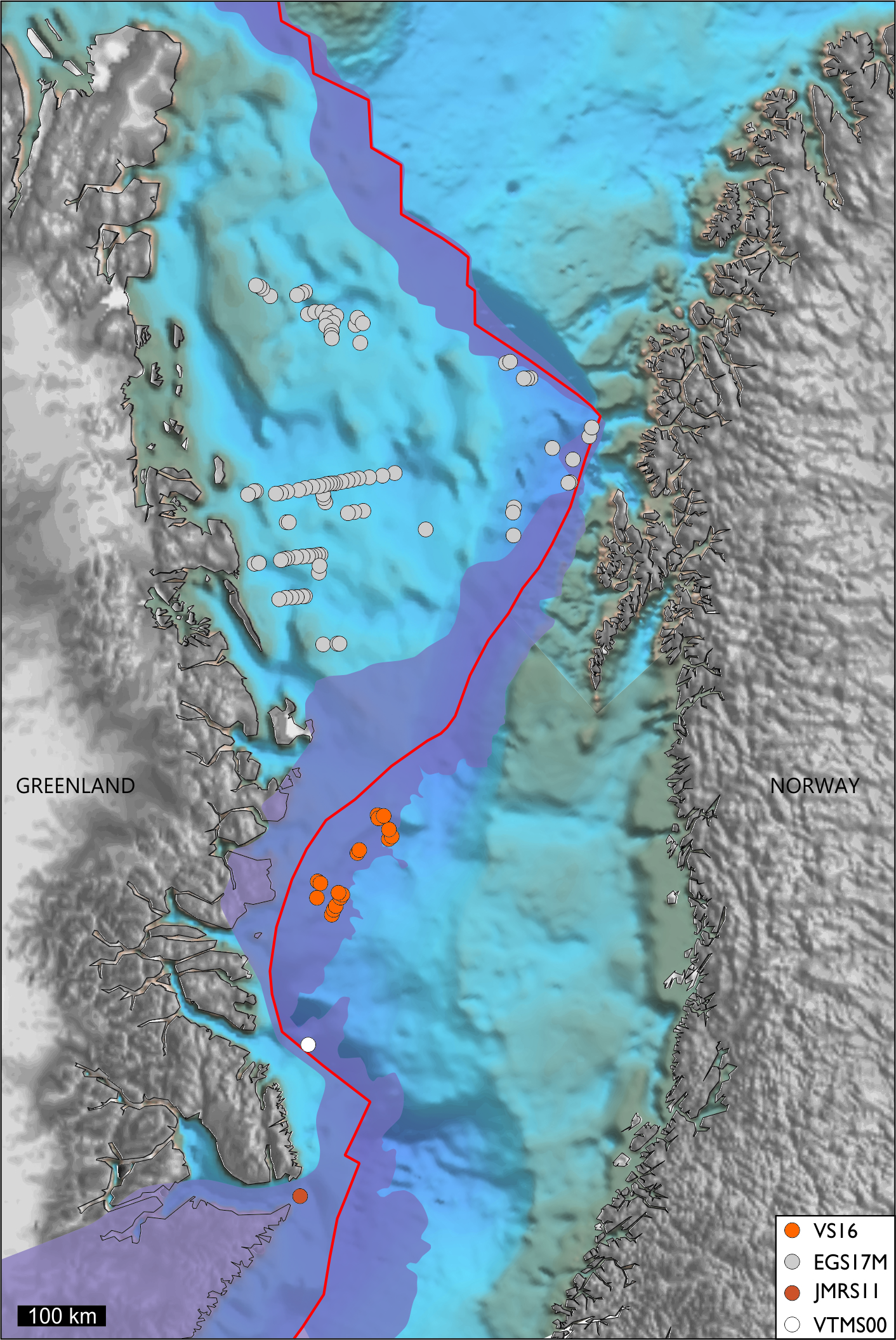
VS16 and other VBER/TGS sampling sites on reconstructed map at breakup time 55 Ma
(map after Trulsvik et al. 2012).
![]()
CONTENTS
Executive Summary
Introduction
- Background and Aims
- Geological Framework
- Sub-Basalt Plays
- Seismic Facies Units
- Petroleum Implications
Hydrocarbon Seepage
- Seepage Styles and Signatures
- Seep Dynamics
- Ascent Mechanisms
- Phase Separation
- Evaluation of Microseep Methods
Operations
- Overview
- M/V Bjørkhaug
- Work and Crew on Bjørkhaug
- Mobilization
- Deployment and Recovery Procedures
- Weather Conditions
Explanatory Notes
- Authorship
- Acknowledgements
- Survey Systems
- Positioning and Navigation System
- Sub-Bottom Profiler (SBP)
- SBP Data Processing
- Coring System
- Gravity Corer
- Underwater Camera System
- Wet Lab
- Sample Handling
- Seep Samples
- Stratigraphic Samples
- Contamination of Seep Samples
- Sample Descriptions
- Geochemistry
- Amplified Geochemical Imaging (AGI)
- Standard Organic Geochemistry (APT)
- Clay
- Extraction
- Deasphaltening
- Iatroscan
- GC Analysis of Gas Components
- GC of EOM Fraction
- GC-MS of Saturated & Aromatic Fractions
- GC-MS/MS of Age Specific Biomarkers
- MPOG (Microbial Prospecting for Oil and Gas)
- Biostratigraphy and Palynology
Results
- Geophysical Data
- Sampling Results
- MPOG
- Sample Sets 100 cm and 10 cm Below Seabed
- Validity of MPOG Results
- AGI
- Geochemical Evaluation
- Hydrocarbon Compound Maps
- Factor Score Trend
- Standard Seep Geochemistry
- Headspace Gas Analysis
- Bulk Extract Geochemistry
- Background Patterns and Hydrocarbon Characterization
- Aromatic and Biomarker Fraction Hydrocarbons
- Maturity and source Parameters
- Age-Related Parameters
- Stratigraphic Studies
- Vesicular Basalt
- Shale Fragments
- Sandstone
Integration and Conclusion
- Introduction
- Seismic Data
- Seep Results
- AGI/MPOG/APT
- Integration
- Petroleum Systems
- Conclusions
Bibliography
Appendix A – Core Descriptions
Digital Data
• pdf version of report
• Seep results in ArcGIS project
• Reprocessed MBE and data